Đánh giá biến động thảm phủ và sử dụng đất khu vực miền trung dựa vào thuật toán ước tính mật độ hạt nhân
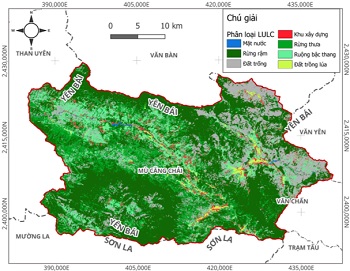
30/08/2021Bài báo này giới thiệu một cách tiếp cận mới trong xây dựng bản đồ thảm phủ và sử dụng đất (LULC) cho khu vực miền Trung từ nhiều nguồn ảnh viễn thám khác nhau. Cách tiếp cận dựa vào thuật toán ước tính mật độ hạt nhân (KDE) để phân loại cho 9 dạng thảm phủ gồm mặt nước, đô thị, lúa, cây hoa màu, cỏ, cây ăn quả, đất trống, rừng và rừng ngập mặn. Kết quả cho thấy, phương pháp KDE có thể tạo ra bản đồ LULC với độ chính xác hơn 90 %. Khoảng 33 ± 18 % diện tích khu vực nghiên cứu xuất hiện sự thay đổi dạng thảm phủ, đặc biệt là rừng và nước mặt tăng mạnh tương ứng 2680 km2 và 570 km2. Đất trống và diện tích lúa giảm tương ứng là 495 km2 và 485 km2 do sự chuyển đổi loại hình canh tác và đô thị hóa. Ngoài ra kết quả cũng cho thấy sử dụng bản đồ toàn cầu cho các nghiên cứu với quy mô địa phương dường như có nhiều sai số và thiếu tính nhất quán. Kết quả của nghiên cứu này rất cần thiết cho phát triển chiến lược quản lý tài nguyên đất và nước.
1. ĐẶT VẤN ĐỀ*
2. SỐ LIỆU VÀ PHƯƠNG PHÁP THỰC HIỆN
2.1. Vùng nghiên cứu
2.2. Dữ liệu và tiền xử lý dữ liệu
2.3. Phương pháp phân loại
3. KẾT QUẢ
4. THẢO LUẬN
5. KẾT LUẬN
TÀI LIỆU THAM KHẢO
[1] N. Torbick, D. Chowdhury, W. Salas, and J. Qi, “Monitoring rice agriculture across myanmar using time series Sentinel-1 assisted by Landsat-8 and PALSAR-2,” Remote Sens., 2017.
[2] J. Dong et al., “Mapping deciduous rubber plantations through integration of PALSAR and multi-temporal Landsat imagery,” Remote Sens. Environ., 2013.
[3] J. Reiche et al., “Combining satellite data for better tropical forest monitoring,” Nature Climate Change. 2016.
[4] J. D. T. De Alban, G. M. Connette, P. Oswald, and E. L. Webb, “Combined Landsat and L-band SAR data improves land cover classification and change detection in dynamic tropical landscapes,” Remote Sens., 2018.
[5] T. T. Hoang and K. N. Nasahara, “Phân Tích Biến Động Thảm Phủ Mặt Đất ở Miền Bắc Việt Nam Sử Dụng Dữ Liệu Viễn Thám Phân Giải Cao,” in Hội thảo khoa học Quốc gia về Khí tượng, Thủy văn, Môi trường và Biến đổi khí hậu, 2017, no. Vi, pp. 445–451.
[6] A. R. As-syakur, I. W. S. Adnyana, I. W. Arthana, and I. W. Nuarsa, “Enhanced built-UP and bareness index (EBBI) for mapping built-UP and bare land in an urban area,” Remote Sens., vol. 4, no. 10, pp. 2957–2970, 2012.
[7] Y. Zha, J. Gao, and S. Ni, “Use of normalized difference built-up index in automatically mapping urban areas from TM imagery,” Int. J. Remote Sens., vol. 24, no. 3, pp. 583–594, 2003.
[8] Hongmei Zhao and Xiaoling Chen, “Use of normalized difference bareness index in quickly mapping bare areas from TM/ETM+,” 2005.
[9] C. J. Tucker, “Red and photographic infrared linear combinations for monitoring vegetation,” Remote Sens. Environ., vol. 8, no. 2, pp. 127–150, 1979.
[10] A. Huete, K. Didan, T. Miura, E. P. Rodriguez, X. Gao, and L. G. Ferreira, “Overview of the radiometric and biophysical performance of the MODIS vegetation indices,” Remote Sens. Environ., vol. 83, no. 1–2, pp. 195–213, 2002.
[11] A. R. Huete, “A soil-adjusted vegetation index (SAVI),” Remote Sens. Environ., vol. 25, no. 3, pp. 295–309, 1988.
[12] T. J. Jackson et al., “Vegetation water content mapping using Landsat data derived normalized difference water index for corn and soybeans,” in Remote Sensing of Environment, 2004.
[13] S. Hashimoto, T. Tadono, M. Onosato, M. Hori, and T. Moriyama, “Probabilistic land cover classification approach toward knowledge-based satellite data interpretations,” in International Geoscience and Remote Sensing Symposium (IGARSS), 2012, pp. 1513–1516.
[14] S. Hashimoto, T. Tadono, M. Onosato, and M. Hori, “Land use and land cover inference in large areas using multi-temporal optical satellite images,” in International Geoscience and Remote Sensing Symposium (IGARSS), 2013.
[15] D. D. Khoi and Y. Murayama, “Forecasting areas vulnerable to forest conversion in the Tam Dao National Park region, Vietnam,” Remote Sens., vol. 2, no. 5, pp. 1249–1272, 2010.
[16] E. S. Nambiar, C. E. Harwood, and N. D. Kien, “Acacia plantations in Vietnam: research and knowledge application to secure a sustainable future,” Southern Forests. 2015.
[17] P. Meyfroidt and E. F. Lambin, “Forest transition in Vietnam and its environmental impacts,” Glob. Chang. Biol., 2008.
[18] FAO, “Global Forest Resources Assessment 2010,” 2010.
Chi tiết bài báo xem tại đây: Đánh giá biến động thảm phủ và sử dụng đất khu vực miền trung dựa vào thuật toán ước tính mật độ hạt nhân
Đỗ Hoài Nam, Phan Cao Dương, Hồ Việt Cường
Viện Khoa học Thủy lợi Việt Nam
TẠP CHÍ KH&CN THỦY LỢI
Ý kiến góp ý:


