Phương pháp phát hiện dịch chuyển theo thời gian thực từ chuỗi dữ liệu định vị GNSS/RTK trong quan trắc biến dạng
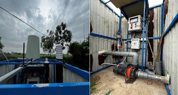
26/03/2026Việc phát hiện dịch chuyển, trượt lở đất đá theo thời gian thực có một ý nghĩa rất lớn trong việc đưa ra cảnh báo để giảm thiểu những rủi ro tai biến do nó gây ra. Trong thời gian gần đây, công nghệ hệ thống vệ tinh dẫn đường toàn cầu (Global Navigation Satellite System - GNSS) với kỹ thuật đo động xử lý tức thời (Real Time Kinematic – RTK) đã được ứng dụng rất có hiệu quả và rộng rãi trong quan trắc, giám sát dịch chuyển theo thời gian thực. Tuy nhiên do ảnh hưởng của nhiễu khi định vị RTK mà chuỗi dữ liệu quan trắc sẽ xuất hiện những giá trị dị thường, dễ nhầm lẫn với giá trị dịch chuyển, gây khó khăn trong việc phát hiện dịch chuyển. Để giải quyết vấn đề này, chúng tôi sử dụng chuỗi dữ liệu định vị GNSS/RTK, được chiết xuất ra theo định dạng tiêu chuẩn NMEA. Sử dụng hai loại tin nhắn GGA và GST của chuỗi dữ liệu này được lọc qua ba bước để loại bỏ nhiễu và các giá trị dị thường sau đó được tính chuyển sang hệ tọa độ vuông góc không gian địa diện chân trời. Phương pháp cửa sổ trượt (Sliding Window – SW) được đề xuất ứng dụng để phân tích chuỗi dữ liệu đã lọc nhiễu sẽ phát hiện ra thời điểm xảy ra chuyển dịch và giá trị chuyển dịch. Một thực nghiệm mô phỏng chuyển dịch được thực hiện với hệ thống thiết bị do chúng tôi thiết kế chế tạo đã minh chứng tính đúng đắn cho phương pháp nghiên cứu đã đề xuất
1. GIỚI THIỆU
2. DỮ LIỆU SỬ DỤNG VÀ PHƯƠNG PHÁP NGHIÊN CỨU
2.1. Định dạng dữ liệu sử dụng trong quan trắc dịch chuyển trượt lở đất đá
2.2. Phương pháp xử lý chuỗi dữ liệu quan trắc theo tiêu chuẩn NMEA
2.3.Phân tích dữ liệu phát hiện dịch chuyển
3. KẾT QUẢ QUAN TRẮC THỰC NGHIỆM MÔ PHỎNG
4. KẾT LUẬN
TÀI LIỆU THAM KHẢO
[1] Jacek Sztubecki; Maria Mrówczynska. Vertical displacement monitoring using the modifed leveling method. Measurement. 2023, 206, 112264. https://doi.org/10.1016/j.measurement.2022.112264.
[2] Niccolo Dematteis; Aleksandra Wrzesniak; Paolo Allasia; Davide Bertolo; Daniele Giordan. Integration of robotic total station and digital image correlation to assess the three-dimensional surface kinematics of a landslide. Engineering Geology. 2002, 303, 106655. https://doi.org/10.1016/j.enggeo.2022.106655.
[3] Aigong Xu; Qiushi Yang; Huizhong Zhu; Meng Gao. Application of GPS technology in surface subsidence monitoring of water extraction. Desalination and Water Treatment. 2021, 241, 207–215. doi: 10.5004/dwt.2021.27791.
[4] Wang Jian; Peng Xiangguo; Xu Chang hui. Coal mining GPS subsidence monitoring technology and its application. Mining Science and Technology (China). 2011, 21, 463-467.
[5] Jiawen Zhou; Nan Jiang; Congjiang Li; Haibo Li. A landslide monitoring method using data from unmanned aerial vehicle and terrestrial laser scanning with insufficient and inaccurate ground control points. Journal of Rock Mechanics and Geotechnical Engineering. 2024, 16, 4125-4140.
[6] Huiyan Lu; Weile Li; Qiang Xu; Wenlong Yu; Shengsen Zhou; Zhigang Li; Weiwei Zhan; Weimin Li; Shanmiao Xu; Pan Zhang; Xiujun Dong; Jingtao Liang; Daqing Ge e. Active landslide detection using integrated remote sensing technologies for a wide region and multiple stages: A case study in southwestern China. Science of the Total Environment. 2024, 931, 172709. https://doi.org/10.1016/j.scitotenv.2024.172709.
[7] Omid Memarian Sorkhabi; Mohammad Khajehzadeh; Suraparb Keawsawasvong. Landslides monitoring with SBAS-InSAR and GNSS. Physics and Chemistry of the Earth. 2023, 123, 103486. https://doi.org/10.1016/j.pce.2023.103486.
[8] Yang Liu, Xin Yao, Zhenkui Gu, Zhenkai Zhou, Xinghong Liu, Shangfei Wei. Study on InSAR image fusion for improved visualization of active landslides in alpine valley areas: A case in the Batang Region, China. Computers & Geosciences. 2024, 186, 105481. https://doi.org/10.1016/j.cageo.2023.105481.
[9] Menghua Li; Lu Zhang; Chao Ding; Weile Li; Heng Luo; Mingsheng Liao; Qiang Xu. Retrieval of historical surface displacements of the Baige landslide from time-series SAR observations for retrospective analysis of the collapse event. Remote Sensing of Environment. 2020, 240, 111695. https://doi.org/10.1016/j.rse.2020.111695.
[10] N. Shen, L.; Chen, J.; Liu, L.; Wang, T.; Tao, D.; Wu, R.; Chen. A review of global navigation satellite system (GNSS)-based dynamic monitoring technologies for structural health monitoring, Remote Sens. 2019, 11 (9), 1001.
[11] Ruijie Xi; Weiping Jiang; Xiaolin Meng; Hua Chena; Qusen Chen. Bridge monitoring using BDS-RTK and GPS-RTK techniques. Measurement. 2018, 20, 128-139. https://doi.org/10.1016/j.measurement.2018.02.001.
[12] N. Quesada-Olmo; M.J. Jimenez-Martinez; M. Farjas-Abadia. Real-time high-rise building monitoring system using global navigation satellite system technology. Measurement. 2018, 123, 115-124. https://doi.org/10.1016/j.measurement.2018.03.054.
[13] J. Rene Vazquez-Ontiveros; Carlos A. Martinez-Felix; G. Esteban Vazquez-Becerra; J. Ramon Gaxiola-Camacho; Angela Melgarejo-Morales; Jorge Padilla-Velazco. Monitoring of local deformations and reservoir water level for a gravity type dam based on GPS observations. Advances in Space Research. 2002. 69 (1), 319-330.
[14] Bao Shu; Yuanhao He; Li Wang; Qin Zhang; Xinrui Li; Xuanyu Qu; Guanwen Huang; Wei Qu. Real-time high-precision landslide displacement monitoring based on a GNSS CORS network. Measurement. 2023, 217, 113056. https://doi.org/10.1016/j.measurement.2023.113056.
[15] Pengxu Wang; Hui Liu; Guigen Nie; Zhixin Yang; Jiaji Wu; Chuang Qian; Bao Shu. Performance evaluation of a real-time high-precision landslide displacement detection algorithm based on GNSS virtual reference station technology. Measurement. 2022, 199, 111457. https://doi.org/10.1016/j.measurement.2022.111457.
[16] K. Gümüş; M.O. Selbesoğlu. Evaluation of NRTK GNSS positioning methods for displacement detection by a newly designed displacement monitoring system, Measurement. 2019, 142 131–137. http://dx.doi.org/10.1016/j.measurement.2019.04.041.
[17] Sermet Ogutcu; Salih Alcay; Huseyin Duman; Behlul Numan Ozdemir; Ceren Konukseven. Static and kinematic PPP-AR performance of low-cost GNSS receiver in monitoring displacements. Advances in Space Research. 2023, 72(11), 4795-4808. https://doi.org/10.1016/j.asr.2023.09.025
[18] Nan Shen; Liang Chen; Ruizhi Chen. Displacement detection based on Bayesian inference from GNSS kinematic positioning for deformation monitoring. Mechanical Systems and Signal Processing. 2022, 167, 108570. https://doi.org/10.1016/j.ymssp.2021.108570.
______________________________________________________________________
Chi tiết bài báo xem tại đây: Phương pháp phát hiện dịch chuyển theo thời gian thực từ chuỗi dữ liệu định vị GNSS/RTK trong quan trắc biến dạng
Phạm Công Khải
Trường Đại học Mỏ - Địa chất
Nguyễn Văn Hải
Trường Đại học Thủy lợi
TẠP CHÍ KH&CN THỦY LỢI
Ý kiến góp ý: